The Company Line
In January 1835 Australian Agricultural Company Commissioner Henry Dumaresq reported that the Assistant Government Surveyor James Ralfe had discovered and marked a favourable line of road, approximately 80 miles in distance, from Gloucester to the Company’s Peel Estate in northern New South Wales over the Great Dividing Range. This could potentially provide an essential path between the two estates. In 1836 Dumaresq reported that William Telfer, the senior Overseer at the Peel Estate, had discovered a better road, travelling up the Barnard River and crossing the Range from there. This road could enable all the Company’s wool to be shipped from Port Stephens, thus avoiding the notorious Great North Road and its bullockies.
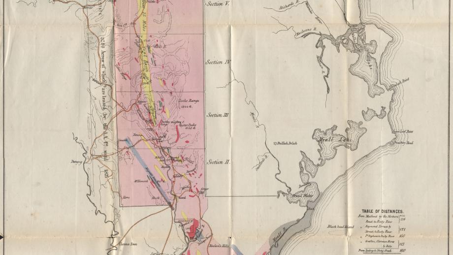
Out stations with yards were formed along the Company Line to assist with moving stock, wool, and stores. These stations included Coneac and Coorabakh (1834), Bowman (1837), and Giro and Upper Bowman (1838). A Superintendent of the Dividing Range was instated at Nowendoc in October 1838. The 1844 Squatting Regulations brought several of these ‘stations’ into the New England Squatting District, and ‘occupation licences’ would thereafter be needed. The Company considered this area useful as pasture when the lower country was in drought, but more importantly, the Company needed this land for its Company Line, with Commissioner King stating “it is highly important in order to command a line of communication between Port Stephens and the Peel, for without it we could not, without endangering the Company flocks from disease, pass sheep from one run to the other” (Despatch 99, 29 May 1844). Consequently, the Company would now need to pay the usual licence of £10 annually, and the assessment of 1d for each sheep.
In 1845 Commissioner Phillip Parker King sent a report compiled by his son Philip Gidley King, the Company’s Stock Manager, recommending the improvement of the Company Line from New England to Port Stephens, especially the ascent of Hungry Hill near Nowendoc. With the Company about to receive its land title, the improvement of the road would enhance its prospects of selling some of its land.
In a report to the Directors in 1848, King proposed that Carrington should be developed for the reception and dispatch of goods, and the re-supply of whaling ships.
The matter of townships was raised again by the Company directors, especially at the Head of Navigation on the Karuah River. Commissioner Ebsworth instigated a survey which recommended a site at North Arm on the harbour or the mouth of The Branch (on the river below Booral), known as Pumpkin Point / Hamilton.
The Company continued efforts to improve the road and committed to undertaking all expenses relating to it through its own estates and dedicating it to public use. By April 1852 Commissioner Archibald Blane reported that some of the Chinese the Company had recently recruited as shepherds were now in a party working to improve the worst passes on the Hungry Hill Road.
Improvements to the Company Line became even more important with the discovery of gold on the Peel Estate in 1852. With the road in good condition, the Company could promote it as a path for those heading inland to the goldfields.
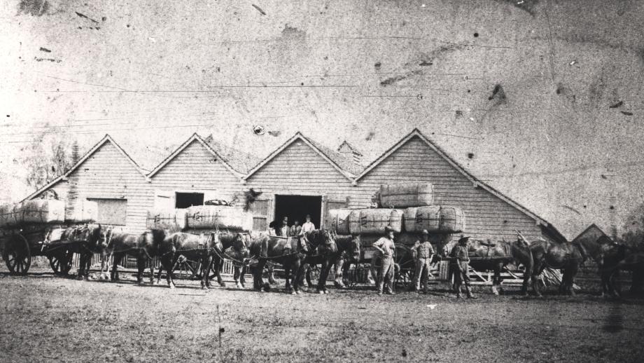
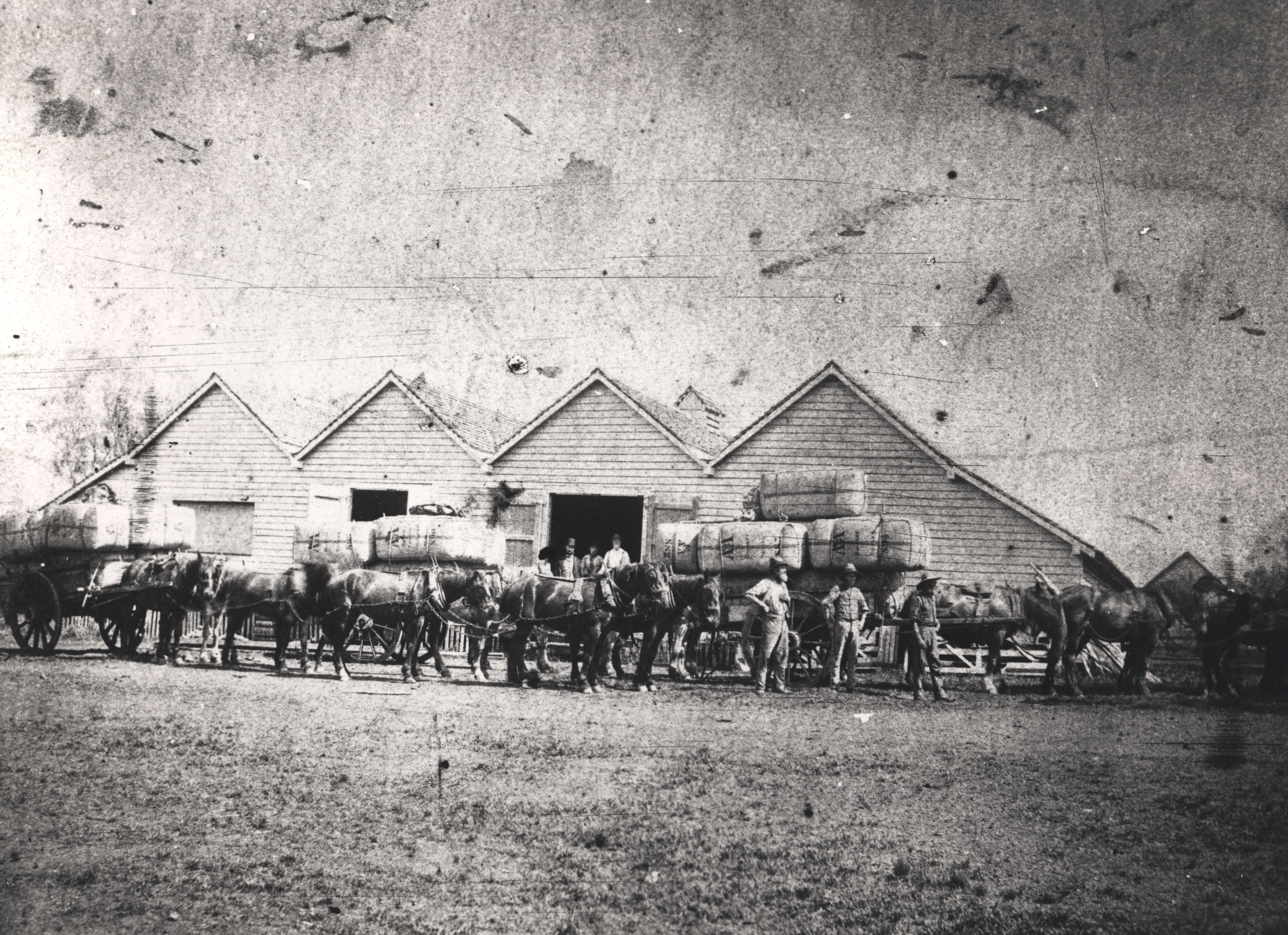
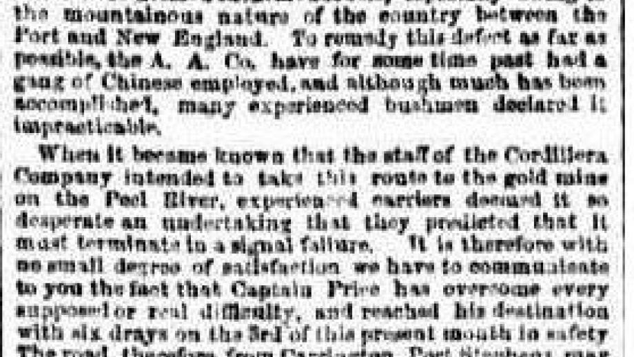
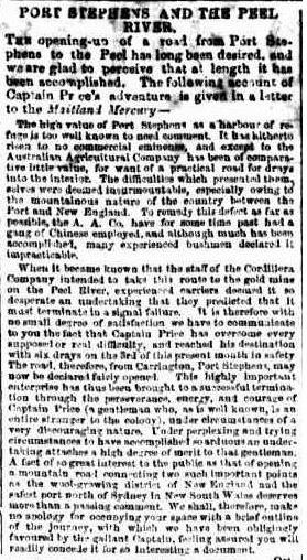
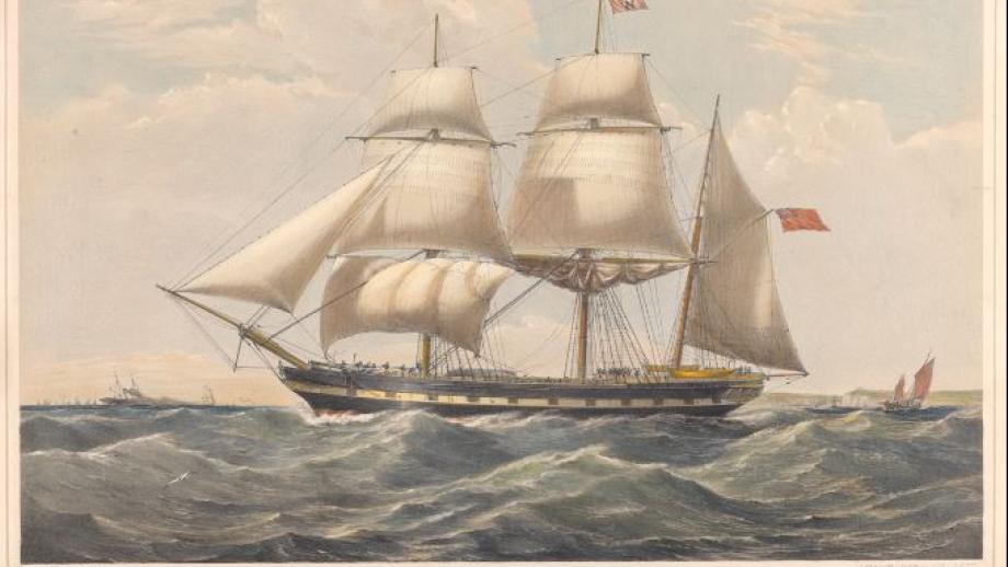
In 1853, the Cordillera Company leased a square mile of the Company’s Peel goldfields and sent an expedition from England on the ship Tory. However, in July 1853, the ship was wrecked off Port Stephens. Tragically one small boy drowned, but the remaining passengers and crew made it ashore. All the Company's machinery was lost at sea. The few that remained keen to head north set off from Stroud on 10 October 1853 along the Company Line, finally reaching the Peel on 3 December. Price sent letters to the both the Australian Agricultural Company and Peel Commissioners to protest the condition of the road.
After much work and advocacy by Commissioner Marcus Brownrigg, the “dray road from New England and the Northern Goldfields, by Stroud to Raymond Terrace” was promoted in land sales, with particularly heavy promotion of the lots at Tahlee and Carrington.
In September 1854, Commissioner Brownrigg advertised the following…
Notice. - A bonus of Ten Pounds will be given by the Australian Agricultural Company to each team bringing down a load of wool during the ensuing season from any part of the northern districts to Port Stephens by the Company's new line of road by way of Gloucester.
The Company have had a gang of twenty men on the road for nearly two years, who have improved the crossing places in the rivers and cut away the sidings on the hills, rendering the road quite practicable. It has already been travelled over at different times during the last year by twelve heavily laden drays.
In his reports on the minerals at Port Stephens in 1855-56, geologist Frederick Odernheimer recommended a tramline from Port Stephens to work the 30-Foot coal seam and iron lode near Stroud. Commissioner Brownrigg approached the Governor Sir William Denison who had £50,000 set aside by the Legislative Council to promote railways and tramways. After considering the matter, Denison directed the Surveyor General to arrange a survey. A team arrived in May 1856, to make a preliminary expedition. From the start it was clear that the focus was Armidale, despite the difficult country, and a rival road was promoted from Armidale to the Clarence River.
As part of this plan, Brownrigg also promoted the building of a coal depot and store at North Arm – to be named ‘Denison’.
By 1858 the survey of the Company Line had reached Giro but was then abandoned after consideration by Commissioner Arthur Hodgson and the visiting Governor E.W.T. Hamilton, and a reservation on land sales one mile each side of the proposed line was removed, allowing a more systematic subdivision of rural blocks.
In 1856 the last sheep left the Company’s Port Stephens Estate, and the land was gradually leased or sold. The link between Port Stephens and the Peel was broken. Carrington was deserted, and an attempt to promote Pumpkin Point / Hamilton as a local port for the New England Line also failed.
The Company’s pastoral runs on the Line, Nowendoc, and Giro were sold unstocked between 1858-60, although in 1859 the Company agreed with the Government to expend £200 each on the road and it was noted that 250 bales of wool from New England passed through Booral / Hamilton.
After this time, the Company Line was rarely mentioned. With the opening of the railway between Maitland and Tamworth in 1878, any need for the road evaporated. The mountainous area, known as The Tops, was eventually settled by Europeans but not until between the 1910s-30s. It wasn’t until the late 1950s that Department of Main Roads and local council built a network of roads to and through Nowendoc.